Indigenous ​activist Autumn Peltier vows to hold feds accountable for 61 boil water advisories​

 OTTAWA — A new documentary that premiered at the Toronto International Film Festival has put a renewed spotlight on an Indigenous clean water advocate known as the “water warrior.”
Autumn Peltier is Anishinaabekwe and a member of Wiikwemkoong First Nation. In 2018, at the age of 13, she pressed world leaders at the United Nations General Assembly on the issue of water protection.
Peltier is the focus of a new short film titled, “The Water Walker.” The film tracks her journey from Wiikwemkoong First Nation in northern Ontario to Manhattan where she spoke at UN headquarters for a second time in 2019 about the importance of universal access to clean drinking water.

A Global Action Plan of Climate Restoration

A GLOBAL ACTION PLAN OF CLIMATE RESTORATION

NATURAL FOREST: USA- State of New Hampshire-Forested areas provide excellent shading, infiltration, and transpiration to regulate small water cycles in the landscape.

A global plan of climate restoration of the “small water cycle” (1) of regional landscapes, with a goal of decreasing floods, drought, natural disasters, and other undesirable climate changes, and increasing the biodiversity and production potential of all continents, through the introduction of various measures of rainwater retention suitable for all areas of human habitation and usage.

Please download full article here: https://goo.gl/FMB9z3

1. WHY IS A GLOBAL ACTION PLAN (GAP) NEEDED?

Water management policies worldwide are typically based on the principle of what can be termed the “old water paradigm,” which assumes among many other considerations, that surface waters are the main source and reserve of fresh water supplies. Global legislation and investment therefore tend to be oriented toward protecting, developing, and utilizing surface waters with infrastructure such as large reservoirs for water collection and distribution. Although rainwater is the cyclical source of all fresh- water supplies, it is nonetheless often considered to be waste product to be drained away quickly into streams and rivers.

There is a need to perceive by way of a “new water paradigm,”(1) that in natural ecosystems, water is integrated into small, regional water cycles, which supply vapor to the atmosphere to condense and form rain, the sun being the driving force of the circulation of water in small water cycles. We also need to appreciate the thermoregulatory processes provided by the movement of water between the surface of the earth and the atmosphere, which maintains the proper temperatures for life on earth.

There needs to be increased attention on the gradual, sometimes almost imperceptible impacts of human activities that have led to the reduction of continental freshwater stocks. There is often a misconception that human activities have no direct effect on water cycles, and that temporal and spatial changes are either part of natural, evolutionary processes, or caused by global climate change. Therefore we tend to underestimate the influence of continental freshwater reserves on global energy and thermoregula- tory processes, as well as the degrading effects of climate change related to excessive drainage of ecosystems. These human impacts can detrimentally affect extensive territories; these include not only traditionally arid landscapes, but also areas of higher rainfall where human infrastructure drains water away from the land, ultimately to accumulate in the oceans.

PORTUGAL-TAMERA – Bernd Mueller is a permaculture and water specialist, and head of Tamera’s ecology project. The focus of the ecological work of Tamera is on building the Water Retention Landscape as a far-reaching approach to healing the land, and regenerating water supplies, topsoil, pasture and forest, and greater diversity of species. See http://www.tamera.org.

It is necessary to retain about 100m3 of rainwater for every inhabitant on the planet. This means that, if every person on earth implemented measures to retain 100m3 of rainwater in their area within one year, enough water retention measures would be achieved to retain more than 760 km3 of water, which would in turn replenish the small water cycles in the atmosphere above land. This aforementioned rainwater, returned to the small water cycles, would lead to a decrease in ocean levels by 3 mm. Even if some doubts exist about the global program’s ability to reduce ocean levels, renew the climate or revive the small water cycles, it is nevertheless legitimate to initiate such a program, based on increased water resources such as that evidenced from an experimental program in the nation of Slovakia. Based on the findings of the Slovakian model, it can be expected that, at the global level, the retention of rainwater on land will result in the increased yield of water resources by more than 30 000 m3 per second and there- fore will kickstart the process of decreasing the production of sensible heat into the atmosphere, with an expected yearly reduction by 500 000 TWh. This will effectively lower the risks of natural disasters as well as occurrences of extreme weather events. More

Right to Water

Without water, life is impossible. Such a basic fact should imply that all human beings have, if they have any rights at all, a fundamental right to water.

And yet, it was not until 2010 that the international community fully and explicitly recognized the right to water.

That year, the UN General Assembly declared that “the right to safe and clean drinking water and sanitation as a human right that is essential for the full enjoyment of life and all human rights,” and called upon states and international organizations to work together to “provide safe, clean, accessible and affordable drinking water and sanitation for all.” Such belated attention highlights the growing awareness of a “global water crisis” that threatens the lives and dignity of billions of people around the world. Although the natural sufficiency of water is a real problem for some parts of the world, the scarcity that drives this crisis is, as the 2006 UN Human Development Report notes, “rooted in power, poverty and inequality, not in physical availability.” As such, addressing the crisis will require the mobilization not only of economic resources and scientific expertise, but of public participation and political courage at all levels of society.

http://unescochair.uconn.edu/2015/10/12/right-to-water-conference/


5Cs Wins Energy Globe Award for Renewable Energy and Potable Water Project in Bequia, St Vincent and the Grenadines

The Caribbean Community Climate Change Centre (CCCCC) received the 2015 Energy Globe Award for its renewable energy and potable water work in Saint Vincent and the Grenadines.

The Cayman Islands should be emulating this initiative and moving towards potable water production for Grand Cayman, Cayman Brac and Little Cayman. Editor

Energy Globe, an internationally recognized trademark for sustainability, is one of the most important environmental prizes today with 177 participating countries. The award, which is made from a cross-section of over 1, 500 entries annually, is given in recognition of outstanding performance in terms of energy efficiency, renewable energy and resource conservation.

The CCCCC won the 2015 Energy Globe National Award for the project “Special Programme for Adaptation to Climate Change”. The project was executed on the island of Bequia in Saint Vincent and the Grenadines and focuses on the production and provision of clean drinking water for more than 1,000 people. This is being done through the acquisition and installation of a reverse osmosis desalination plant. The project is deemed highly sustainable as the water input is inexhaustible sea water and the energy used is solar, a renewable, carbon-free source.

The landmark project was also presented by Energy Globe as part of a global online campaign (www.energyglobe.info) on World Environment Day. The campaign ran under the patronage of UNESCO and in cooperation with UNEP and received significant recognition.

“To be honoured with this award is a great recognition of our work for a better environment and motivates us to continue our endeavours in the future,” – Henrik Personn, Renewable Energy Expert, CCCCC

Since completing this key project, we have applied the lessons learned in Belize and on the Grenadian islands of Petite Martinique and Carriacou. Review the poster above to learn more about the progress we are making in Grenada:


Tufton Wants Laws On Water Harvesting

EFFORTS TO preserve the country’s water reserves must be supplemented by legislation that makes rainwater harvesting compulsory for all housing developments and other such major projects which put a drain on Jamaica’s limited water resources during construction.

Dr Christopher Tufton

That is the recommendation from Dr Christopher Tufton, who told The Gleaner that such legislation is overdue, given Government’s failure to examine and report back on a resolution passed in the Senate March 1, 2013 on legislating rainwater harvesting.

“This is yet another example of a country that gives lip service to sustainable development, while citizens have to experience the hardships from a water crisis each year. We have heard nothing of the resolution since then, and as is customary, we act surprised that we are in another water shortage crisis, even though we have this situation each year,” said the former government minister.

He wants to make it mandatory that developers include in their applications information on how they will harvest and store rainwater for use during the life of the project. The legislation also speaks to the incorporation of features such as guttering on individual buildings, to ensure that water conservation becomes a part the Jamaican culture going forward.

“What it would mean is that one could determine to what extent existing projects could be retrofitted or adjusted. For new projects, however, part of their design should include a rainwater harvesting process. Now, it does add to the cost of construction, but in some countries, they have done things like tax rebates, among other things, to incentivise developers,” Tufton said. “So once construction is done, you could get a tax write-off in a short period of time to keep costs to a minimum.”

Acknowledging that this additional cost might prove a deterrent for some investors, Tufton said one has to look at the much bigger picture of the emotional distress and financial fallout the country is now experiencing. More


New NASA data show how the world is running out of water

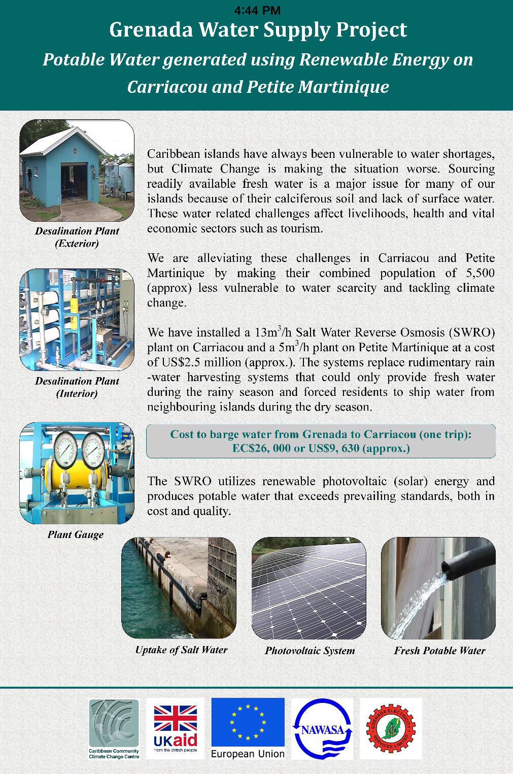
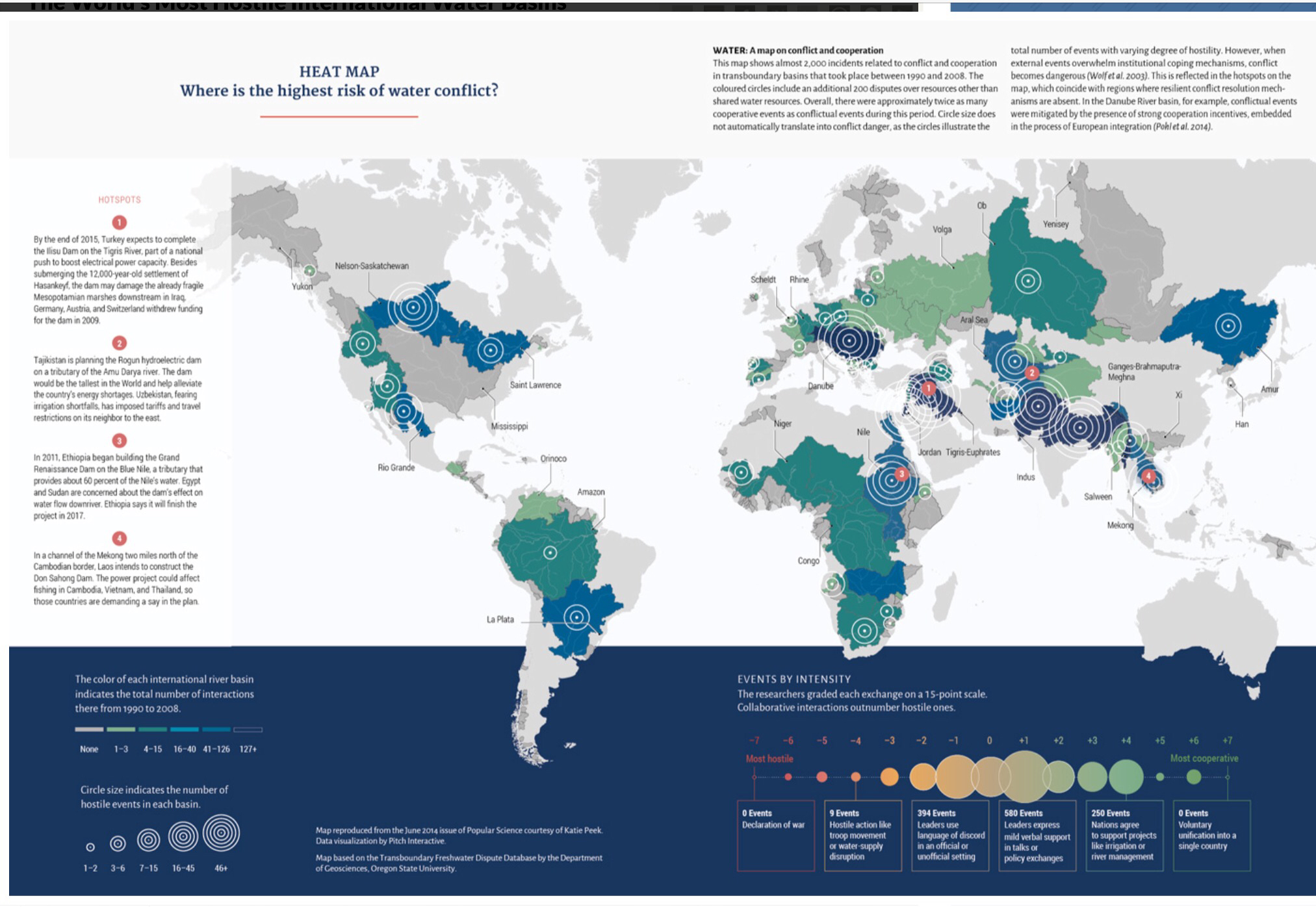
The world’s largest underground aquifers – a source of fresh water for hundreds of millions of people — are being depleted at alarming rates, according to new NASA satellite data that provides the most detailed picture yet of vital water reserves hidden under the Earth’s surface.

Twenty-one of the world’s 37 largest aquifers — in locations from India and China to the United States and France — have passed their sustainability tipping points, meaning more water was removed than replaced during the decade-long study period, researchers announced Tuesday. Thirteen aquifers declined at rates that put them into the most troubled category. The researchers said this indicated a long-term problem that’s likely to worsen as reliance on aquifers grows.

Scientists had long suspected that humans were taxing the world’s underground water supply, but the NASA data was the first detailed assessment to demonstrate that major aquifers were indeed struggling to keep pace with demands from agriculture, growing populations, and industries such as mining.

“The situation is quite critical,” said Jay Famiglietti, senior water scientist at NASA’s Jet Propulsion Laboratory in California and principal investigator of the University of California Irvine-led studies.

Underground aquifers supply 35 percent of the water used by humans worldwide. Demand is even greater in times of drought. Rain-starved California is currently tapping aquifers for 60 percent of its water use as its rivers and above-ground reservoirs dry up, a steep increase from the usual 40 percent. Some expect water from aquifers will account for virtually every drop of the state’s fresh water supply by year end

The aquifers under the most stress are in poor, densely populated regions, such as northwest India, Pakistan and North Africa, where alternatives are limited and water shortages could quickly lead to instability.

The researchers used NASA’s GRACE satellites to take precise measurements of the world’s groundwater aquifers. The satellites detected subtle changes in the Earth’s gravitational pull, noting where the heavier weight of water exerted a greater pull on the orbiting spacecraft. Slight changes in aquifer water levels were charted over a decade, from 2003 to 2013.

“This has really been our first chance to see how these large reservoirs change over time,” said Gordon Grant, a research hydrologist at Oregon State University, who was not involved in the studies.

But the NASA satellites could not measure the total capacity of the aquifers. The size of these tucked-away water supplies remains something of a mystery. Still, the satellite data indicated that some aquifers may be much smaller than previously believed, and most estimates of aquifer reserves have “uncertainty ranges across orders of magnitude,” according to the research.

Aquifers can take thousands of years to fill up and only slowly recharge with water from snowmelt and rains. Now, as drilling for water has taken off across the globe, the hidden water reservoirs are being stressed.

“The water table is dropping all over the world,” Famiglietti said. “There’s not an infinite supply of water.”

The health of the world’s aquifers varied widely, mostly dependent on how they were used. In Australia, for example, the Canning Basin in the country’s western end had the third-highest rate of depletion in the world. But the Great Artesian Basin to the east was among the healthiest.

The difference, the studies found, is likely attributable to heavy gold and iron ore mining and oil and gas exploration near the Canning Basin. Those are water-intensive activities.

The world’s most stressed aquifer — defined as suffering rapid depletion with little or no sign of recharging — was the Arabian Aquifer, a water source used by more than 60 million people. That was followed by the Indus Basin in India and Pakistan, then the Murzuk-Djado Basin in Libya and Niger.

California’s Central Valley Aquifer was the most troubled in the United States. It is being drained to irrigate farm fields, where drought has led to an explosion in the number of water wells being drilled. California only last year passed its first extensive groundwater regulations. But the new law could take two decades to take full effect.

Also running a negative balance was the Atlantic and Gulf Coastal Plains Aquifer, which stretches across the southeast coast and Florida. But three other aquifers in the middle of the country appeared to be in relatively good shape.

Some groundwater filters back down to aquifers, such as with field irrigation. But most of it is lost to evaporation or ends up being deposited in oceans, making it harder to use. A 2012 study by Japanese researchers attributed up to 40 percent of the observed sea-level rise in recent decades to groundwater that had been pumped out, used by humans and ended up in the ocean.

Famiglietti said problems with groundwater are exacerbated by global warming, which has caused the regions closest to the equator to get drier and more extreme latitudes to experience wetter and heavier rains. A self-reinforcing cycle begins. People living in mid-range latitudes not only pump more water from aquifers to contend with drier conditions, but that water — once removed from the ground — also then evaporates and gets recirculated to areas far north and south.

The studies were published Tuesday in the Water Resources Research journal.

Famiglietti said he hoped the findings would spur discussion and further research into how much groundwater is left.

“We need to get our heads together on how we manage groundwater,” he said, “because we’re running out of it.” More


The World’s Most Hostile International Water Basins

At the launch of A New Climate for Peace, a new report on climate-fragility risks produced for the G7 by a consortium of international partners including the Wilson Center, USAID Deputy Assistant Administrator Christian Holmes called water a common denominator for climate risk.

“How you manage your water programs…has a huge amount to do with how you mitigate the prospect for increased fragility,” he said. “Sometimes it’s the obvious that’s so easy to miss, and I think that the obvious on water as it relates to economic development is, essentially, the question of sustainable water supply.”

One of the most striking infographics from A New Climate for Peace touches on that question of supply. Using data from Oregon State University’s Transboundary Freshwater Dispute Database and adapted from a graphic that originally appeared in Popular Sciencelast year, the map shows the world’s most active – and tension-filled – international water basins.

Water is a common denominator for climate risk

The Transboundary Freshwater Dispute Database measures not only the frequency of hostile events in a basin, but cooperative ones as well, each on a sliding scale. Hostile events range from declarations of war (zero recorded from 1990 to 2008, the period of time encompassed by the graphic) to leaders using “language of discord.” Cooperative events range from “mild verbal support” to “voluntary unification into a single country.”

The total number of events is indicated by shades of blue – the darker the blue, the more transboundary events, both positive and negative. This is essentially the “hot list” of international water basins – which regions have the most official and unofficial chatter over water.

Circles superimposed on the basins represent the total number of hostile events. As the description text points out, however, “circle size does not automatically translate into conflict danger.” In some places, transboundary institutions and diplomatic frameworks allow different actors to work through their differences. Cooperative hostility, if you will. In the Danube River Basin, for example, the high number of “hostile” events is mitigated by strong cooperative incentives associated with European integration. Likewise in North America, where Canada, the United States, and Mexico share several basins with a high number of hostile events, there is little chance of violent conflict.

Water basins in South Asia, the Middle East, and East Africa are major hotspots with a high number of hostile events and weaker institutional frameworks to mitigate them. The Indus, Ganges-Brahmaputra-Meghna, Salween, Tigris-Euphrates, and Jordan basins witness a very high number of interactions, suggesting at least that continued dialogue could be a way forward to mitigate the risk of violent conflict or fragility. The Nile Basin has less activity reflecting the stalled negotiations between the basin’s 10 member states to replace colonial-era water agreements. The Mekong Basin, where the largest member, China, does not participate as a full member of the Mekong River Commission, shows less activity as well.

The map does a great job illustrating why it can be difficult to answer the question, where is the highest risk of water-related violence? Tensions between states and other freshwater basin actors isn’t necessarily a sign of impending violence if there’s a framework to resolve them. Likewise, lack of communication over a major natural resource can be a bad sign for cooperation when the resource in question is the Nile. More

More infographics from ‘A New Climate for Peace: Taking Action on Climate and Fragility Risks’ are available on NewClimateforPeace.org.


Century of Water Shortage Ahead? Lake Mead Drops Below Rationing Line For First Time in Its History.

Lake Mead Drops Below Rationing Line For First Time in Its History.

1075 feet. That’s the water level Lake Mead must stay above before mandatory multi-state water rationing goes into effect. A level just 25 feet above the highest intake pipe used to supply cities across the Desert Southwest. Last night water levels at the key national water storage facility fell below that hard line to 1074.99 feet — a record low never before seen in all of its history.

If water levels remain below the 1075 foot mark through January of 2016, then a multi-state rationing will go into effect (with most acute impacts for Arizona and Nevada). A rationing that will have serious consequences for desert cities across the Southwest, cities like Las Vegas which rely on Lake Mead for so much of their water.

Despite Lake Mead hitting the 1075 hard line, it appears that rationing may be forestalled through 2016. It’s a silver lining of all the severe summer storms that have rolled through the Colorado River Basin this spring and summer — pumping up water flows to Lake Mead and Lake Powell. A flush of much needed moisture that will, hopefully, prevent water rationing from going into effect during 2016. But prospects for the future, despite this temporary respite, are starting to look a bit grim.

Risk of Future Megadrought

The trend set in place by a human-forced warming of the Desert Southwest has resulted in an increasing number of dry years. The added heat forces water to evaporate more rapidly. So even when it does rain an average amount, moisture levels still fall. The result is not only an increase in single year droughts, but an increased risk of decadal droughts (called megadroughts).

As the years progress and more of the impacts of human-forced global warming become apparent, the drought impacts and severe drought risks are only expected to rise. For according to a recent Cornell University report (2014) the chance of a 10 year drought for the US Southwest under a moderate warming scenario (RCP 4.5) is 50% this century (greater for states like Texas, Oklahoma, New Mexico, Arizona, and Nevada — see graphic below). The chances of a 30 year drought range from 20-50 percent depending on the severity of the human greenhouse gas emission. More


Parched Caribbean faces widespread drought, water shortages

The worst drought in five years is creeping across the Caribbean, prompting officials around the region to brace for a bone dry summer.

From Puerto Rico to Cuba to the eastern Caribbean island of St. Lucia, crops are withering, reservoirs are drying up and cattle are dying while forecasters worry that the situation could only grow worse in the coming months.

Thanks to El Nino, a warming of the tropical Pacific that affects global weather, and a quieter-than-normal hurricane season that began in June, forecasters expect a shorter wet season. That means less rain to help refill Puerto Rico's thirsty Carraizo and La Plata reservoirs as well as the La Plata river in the central island community of Naranjito. A tropical disturbance that hit the U.S. territory on Monday did not fill up those reservoirs as officials had anticipated.

Puerto Rico is among the Caribbean islands worst-hit by the , with more than 1.5 million people affected by the drought so far, according to the U.S. National Drought Mitigation Center.

Tens of thousands of people receive water only every third day under strict rationing recently imposed by the island government. Puerto Rico last week also activated National Guard troops to help distribute water and approved a resolution to impose fines on people and businesses for improper water use.

The Caribbean's last severe drought was in 2010. The current one could grow worse if the hurricane season ending in November produces scant rainfall and the region enters the dry season with parched reservoirs, said Cedric Van Meerbeeck, a climatologist with the Caribbean Institute for Meteorology and Hydrology.

“We might have serious water shortages … for irrigation of crops, firefighting, domestic consumption or consumption by the hotel sector,” he said.

The Caribbean isn't the only area in the Western Hemisphere dealing with extreme water shortages. Brazil has been struggling with its own severe drought that has drained reservoirs serving the metropolis of Sao Paulo.

In the Caribbean, the farm sector has lost more than $1 million in crops as well as tens of thousands of dollars in livestock, said Norman Gibson, scientific officer at the Trinidad-based Caribbean Agricultural Research and Development Institute.

On St. Lucia, which has been especially hard hit, farmers say crops including coconuts, cashews and oranges are withering.

“The outlook is very, very bad,” said Anthony Herman, who oversees a local farm cooperative. “The trees are dying, the plants are dying … It's stripping the very life of rivers.”

Officials in Cuba say 75 percent of the island is enduring a drought that has killed cattle and destroyed thousands of hectares (acres) of crops including plantains, citrus, rice and beans. Recent heavy rains in some areas have alleviated the problem some, but all 200 government-run reservoirs are far below capacity.

In the nearby Dominican Republic, water shortages have been reported in hundreds of communities, said Martin Melendez, a civil engineer and hydrology expert who has worked as a government consultant. “We were 30 days away from the entire water system collapsing,” he said.

The tourism sector has also been affected.

Most large hotels in Puerto Rico have big water tanks and some recycle wastewater to irrigate green areas, but many have curtailed water use, said Frank Comito, CEO of the Florida-based Caribbean Hotel & Tourism Association.

Other hotels have cut back on sprinkler time by up to 50 percent, said Carlos Martinez of Puerto Rico's Association of Hotels. “Everybody here is worried,” he said. “They are selling water tanks like hot cakes … and begging God for rain.”

Guests at Puerto Rico's El Canario by the Lagoon hotel get a note with their room keys asking them to keep their showers short amid the water shortage. “We need your cooperation to avoid waste,” says the message distributed at the front desk of the hotel in the popular Condado district.

At the Casa del Vega guesthouse in St. Lucia, tourists sometimes find the in their rooms turned off for the day, preventing them from taking a shower. “Even though we have a drought guests are not sympathetic to that,” hotel manager Merlyn Compton said. More


Dry Heat

Last week, Lake Mead, which sits on the border of Nevada and Arizona, set a new record low—the first time since the construction of the Hoover Dam in the 1930s that the lake’s surface has dipped below 1,080 feet above sea level.

The West’s drought is so bad that official plans for water rationing have now begun—with Arizona’s farmers first on the chopping block. Yes, despite the drought’s epicenter in California, it’s Arizona that will bear the brunt of the West’s epic dry spell.

The huge Lake Mead—which used to be the nation’s largest reservoir—serves as the main water storage facility on the Colorado River. Amid one of the worst droughts in millennia, record lows at Lake Mead are becoming an annual event—last year’s low was 7 feet higher than this year’s expected June nadir, 1,073 feet.

If, come Jan. 1, Lake Mead’s level is below 1,075 feet, the U.S. Bureau of Reclamation, which manages the river, will declare an official shortage for the first time ever—setting into motion a series of already agreed-upon mandatory cuts in water outlays, primarily to Arizona. (Nevada and Mexico will also receive smaller cuts.) The latest forecasts give a 33 percent chance of this happening. There’s a greater than 75 percent chance of the same scenario on Jan. 1, 2017. Barring a sudden unexpected end to the drought, official shortage conditions are likely for the indefinite future.

Why Arizona? In exchange for agreeing to be the first in line for rationing when a shortage occurs, Arizona was permitted in the 1960s to build the Central Arizona Project, which diverts Colorado River water 336 miles over 3,000 feet of mountain ranges all the way to Tucson. It’s the longest and costliest aqueduct in American history, and Arizona couldn’t exist in its modern state without it. Now that a shortage is imminent, another fundamental change in the status quo is on the way. As in California, the current drought may take a considerable and lasting toll on Arizona, especially for the state’s farmers.

“We need to stop growing alfalfa in the deserts in the summertime.”

Robert Glennon, water policy expert at the University of Arizona

“A call on the river will be significant,” Joe Sigg, director of government relations for Arizona Farm Bureau, told the Arizona Daily Star. “It will be a complete change in a farmer’s business model.” A “call” refers to the mandatory cutbacks in water deliveries for certain low-priority users of the Colorado. Arizona law prioritizes cities, industry, and tribal interests above agriculture, so farmers will see the biggest cuts. And those who are lucky enough to keep their water will pay more for it.

According to Robert Glennon, a water policy expert at the University of Arizona, the current situation was inevitable. “It’s really no surprise that this day was coming, for the simple reason that the Colorado River is overallocated,” Glennon told me over the phone last week. Glennon explained that the original Colorado River compact of 1922, which governs how seven states and Mexico use the river, was negotiated during “the wettest 10-year period in the last 1,000 years.” That law portioned out about 25 percent more water than regularly flows, so even in “normal” years, big reservoirs like Lake Mead are in a long-term decline. “We’ve been saved from the disaster because Arizona and these other states were not using all their water,” Glennon said.

They are now. Since around 2000, Arizona has been withdrawing its full allotment from the Colorado River, and it’s impossible to overstate how important the Colorado has become to the state. About 40 percent of Arizona’s water comes from the Colorado, and state officials partially attribute a nearly 20-fold increase in the state’s economy over the last 50 years to increased access to the river.

On April 22, Arizona held a public meeting to prepare for an eventual shortage declaration, which could come as soon as this August. The latest rules that govern a shortage, established in 2007 by an agreement among the states, say that Arizona will have to contend with a 20 percent cut in water in 2016 should Lake Mead fall below 1,075 feet, which will decrease the amount available to central Arizona’s farmers by about half. At 1,050 feet, central Arizona’s farmers will take a three-quarters cut in water. At 1,025 feet, agriculture would have to make due largely without water from the Colorado River. That would probably require at least a temporary end to large-scale farming in central Arizona. Below 1,025 feet, the only thing Colorado River states have agreed to so far is a further round of negotiations. In that emergency scenario, no one really knows what might happen. More